
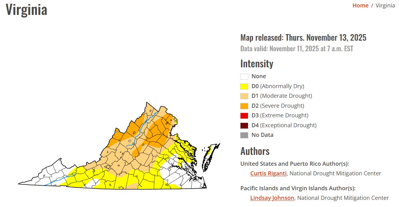
Orange County remains in a severe drought, part of a dry spell that began in early August and has intensified through the fall. Aside from a few brief showers, the region has seen little meaningful rainfall. From August through mid-November, the county typically receives about 12 inches of rain. This year, totals are closer to 5 inches — roughly 7 inches below normal.
As of Nov. 15, federal drought monitors list most of Orange County in Severe Drought, the second of four drought intensity categories.
One mitigating factor has been slightly cooler temperatures since late summer. Lower heat has slowed evaporation and prevented conditions from becoming even worse. Had August and September reached their usual highs, drought severity would likely be more extreme.
Drought status is determined by comparing recent rainfall with long-term averages. The U.S. Drought Monitor — a partnership between the National Drought Mitigation Center, the U.S. Department of Agriculture and the National Weather Service — releases updated assessments each Thursday. Virginia’s current map is available on the Drought Monitor website.
While the drought arrived after most of the county’s primary growing season, continued dryness poses several risks. Groundwater, streams and local reservoirs could drop to levels that strain wells and public water supplies. Smaller farm ponds are already receding more quickly than usual.
Wildfire danger is also elevated. With dry leaves blanketing the ground and humidity levels falling, windy days can accelerate fire spread. The National Weather Service may issue fire-weather alerts in these conditions, and if the pattern persists, state officials could enact outdoor burn restrictions.
The National Weather Service issues two types of fire-weather advisories:
Fire Weather Watch — possible the following day when
• sustained winds exceed 25 mph,
• relative humidity drops to 30% or lower,
• 10-hour fuel moisture falls below 8%,
OR winds exceed 35 mph.
Red Flag Warning — expected within 24 hours when the same conditions are more certain.
Officials encourage residents to monitor local forecasts, use caution with outdoor burning, and remain aware of changing conditions as the region heads toward winter with a significant rainfall deficit.

Hi! I’m Jennifer Bailey and I partner with entrepreneurs who have massive ideas that could change the world. Most marketing is meaningless. Filled with empty promises, its only job is to bring in new traffic, new leads, and new customers. But I’ve drawn a line in the sand, and I’ve learned that marketing can do so much more than reach business goals and build profit. My methods give businesses the fire and soul they need to reach the right people, set the groundwork for sustainable relationships, and offer true value to the people on both the giving and receiving ends of marketing.
Subscribe for Updates
Sponsors


Latest Articles
December 31, 2025
Letter from the Editor: Data Centers

December 31, 2025
Airport Expansion Marks Major Infrastructure Investment in Orange County
December 31, 2025
Region’s Largest Tandem Skydiving Center is Here in Orange

December 31, 2025
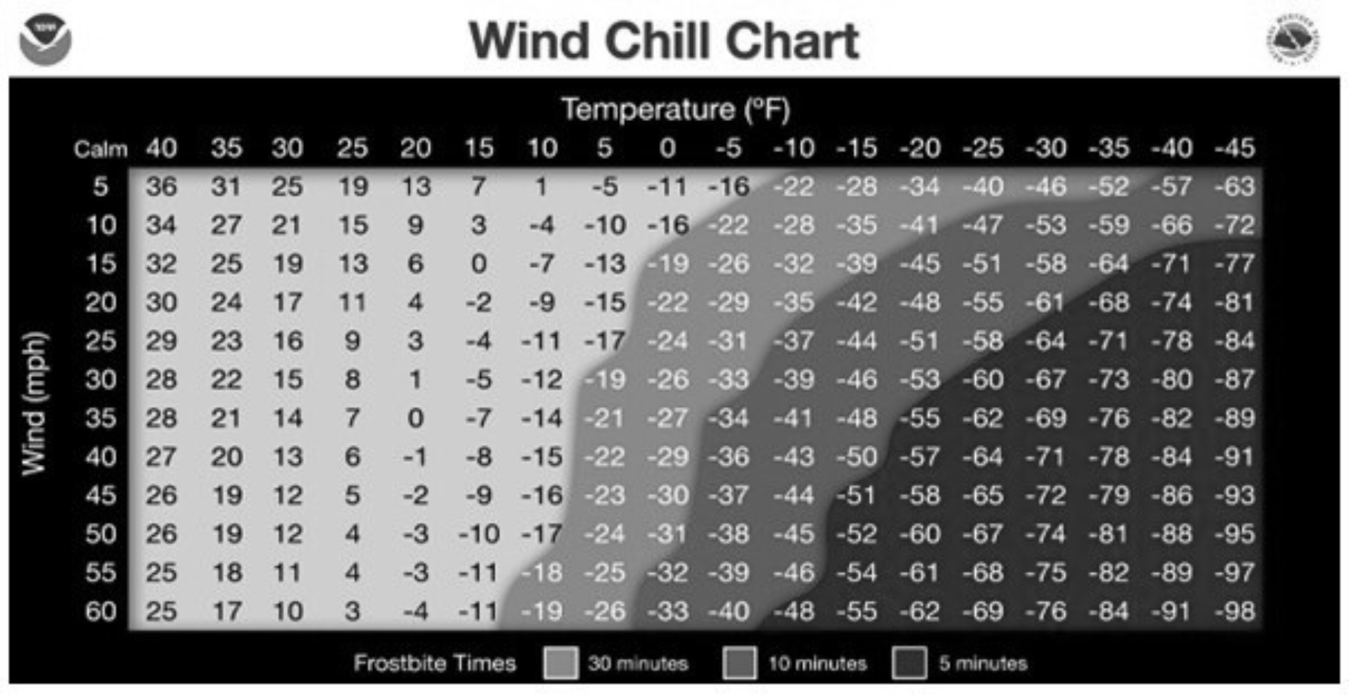
Winter Safety: Understanding Wind Chill Hypothermia
December 31, 2025
Sweet Reasons Brings National Spotlight to Local Baking

December 31, 2025
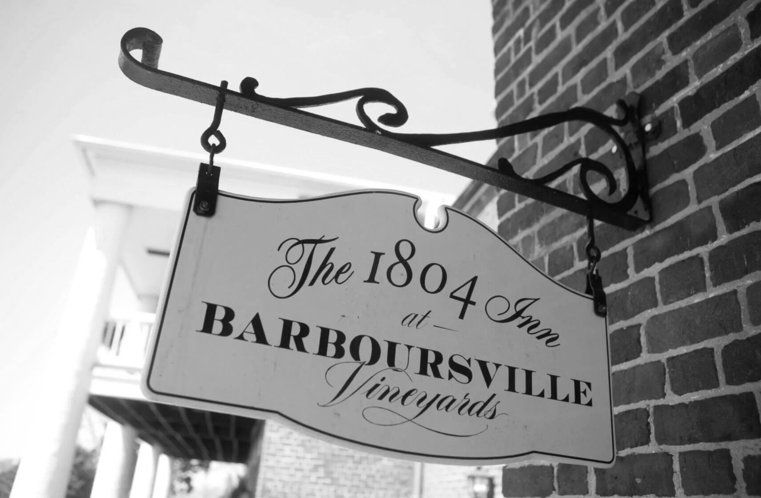
Wine, Firelight, History:Inside a Stay at Barboursville Vineyard’s 1804 Inn
Orange County remains in a severe drought, part of a dry spell that began in early August and has intensified through the fall. Aside from a few brief showers, the region has seen little meaningful rainfall. From August through mid-November, the county typically receives about 12 inches of rain. This year, totals are closer to 5 inches — roughly 7 inches below normal.
As of Nov. 15, federal drought monitors list most of Orange County in Severe Drought, the second of four drought intensity categories.
One mitigating factor has been slightly cooler temperatures since late summer. Lower heat has slowed evaporation and prevented conditions from becoming even worse. Had August and September reached their usual highs, drought severity would likely be more extreme.
Drought status is determined by comparing recent rainfall with long-term averages. The U.S. Drought Monitor — a partnership between the National Drought Mitigation Center, the U.S. Department of Agriculture and the National Weather Service — releases updated assessments each Thursday. Virginia’s current map is available on the Drought Monitor website.
While the drought arrived after most of the county’s primary growing season, continued dryness poses several risks. Groundwater, streams and local reservoirs could drop to levels that strain wells and public water supplies. Smaller farm ponds are already receding more quickly than usual.
Wildfire danger is also elevated. With dry leaves blanketing the ground and humidity levels falling, windy days can accelerate fire spread. The National Weather Service may issue fire-weather alerts in these conditions, and if the pattern persists, state officials could enact outdoor burn restrictions.
The National Weather Service issues two types of fire-weather advisories:
Fire Weather Watch — possible the following day when
• sustained winds exceed 25 mph,
• relative humidity drops to 30% or lower,
• 10-hour fuel moisture falls below 8%,
OR winds exceed 35 mph.
Red Flag Warning — expected within 24 hours when the same conditions are more certain.
Officials encourage residents to monitor local forecasts, use caution with outdoor burning, and remain aware of changing conditions as the region heads toward winter with a significant rainfall deficit.
Hi! I’m Jennifer Bailey and I partner with entrepreneurs who have massive ideas that could change the world. Most marketing is meaningless. Filled with empty promises, its only job is to bring in new traffic, new leads, and new customers. But I’ve drawn a line in the sand, and I’ve learned that marketing can do so much more than reach business goals and build profit. My methods give businesses the fire and soul they need to reach the right people, set the groundwork for sustainable relationships, and offer true value to the people on both the giving and receiving ends of marketing.
Subscribe for Updates
Sponsors
latest articles
December 31, 2025
Letter from the Editor: Data Centers
December 31, 2025
Airport Expansion Marks Major Infrastructure Investment in Orange County
December 31, 2025
Region’s Largest Tandem Skydiving Center is Here in Orange
December 31, 2025
Winter Safety: Understanding Wind Chill Hypothermia
December 31, 2025
Sweet Reasons Brings National Spotlight to Local Baking
December 31, 2025
Wine, Firelight, History:Inside a Stay at Barboursville Vineyard’s 1804 Inn
Region’s Largest Tandem Skydiving Center is Here in Orange
For nearly five decades, Skydive Orange has been inviting people to do something most only imagine: step to the edge,…
Article By Jen Bailey

Behind the Curtain: a Thriving Drama Program at OCHS
At Orange County High School, the drama program is far more than brilliant lighting, impressive set design and curtain calls.…
Article By Doug Ponton

Orange County Considers New Technology Zoning District to Regulate Data Center Development
Orange County officials are advancing a proposed zoning change aimed at regulating how data centers could be developed in the…